The Quiet Work of a Watershed Boundary
A watershed boundary separates land draining to different outlets. Learn to trace its subtle line on a map and see which stream a slope feeds.
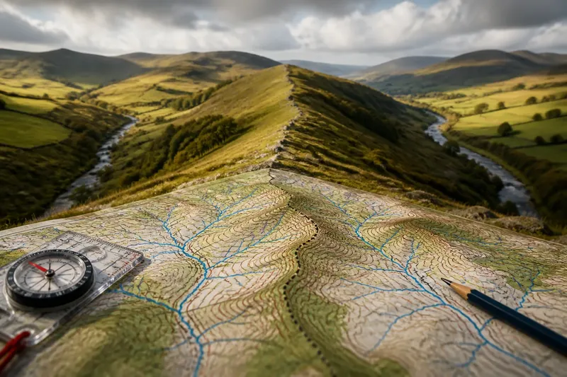
Where does rain go when it lands on a ridge? A watershed boundary separates the land that drains into one network of streams from land that drains into another. You may cross it without noticing: the dividing line can follow a low, rounded rise beneath woodland, fields or streets rather than a dramatic mountain crest.
The boundary is the line or transition between drainage areas; the high ground helps direct water to either side. Unlike a wall or painted border, this divide works through gravity. Water falling on one side tends towards one stream network, while water on the other side tends towards another.
What does a watershed boundary separate?
A watershed boundary is the dividing line between areas that drain towards different outlets. The land enclosed by that line is a watershed, also called a drainage basin or catchment. The terms can vary by region and context, but the central idea is that water within a basin flows towards a shared outlet, such as a river mouth, lake or inland depression.
Imagine tipping a little water onto a sloping roof. The roof’s ridge directs drops towards one gutter or the other; a watershed divide does similar work across natural terrain. The analogy has limits, because real ground contains hollows, wetlands, soil and underground routes, but it helps explain the basic direction of flow.
On a map, the boundary generally follows higher ground between drainage networks. It may separate two small streams or mark the divide between much larger river systems. It is not always a single sharp crest: broad uplands can form a zone where the precise line is less obvious.
How does a subtle ridge direct rainwater?
Rain moves downhill under gravity, following the local slope. Near a ridge, a small difference in the ground’s tilt can send water towards opposite sides. It may soak into soil, collect in a hollow, join a trickle and then enter a stream.
Water gathers from many small slopes into a branching network. Minor channels feed larger ones, and those join still larger rivers. The watershed boundary marks the outer limit of the land contributing water to one drainage network; it does not run along the river itself.
Not every raindrop follows a visible channel straight away. Some water remains in vegetation, enters the soil or moves below ground before reaching a stream. During heavy rain, surface flow may appear in places that are usually dry, while ditches, roads and culverts can redirect water locally.
How can you trace a watershed boundary on a map?
Start with the streams, then trace the higher ground between their valleys. On a topographic map, contour lines show elevation; a divide tends to follow ridges and rounded highs. Streams usually occupy lower ground, where contour lines form V-shapes pointing uphill.
Work back from an outlet: trace the river upstream, note its tributaries, then identify the higher terrain enclosing them. Compare that area with the neighbouring basin. The boundary lies between the two drainage systems, along the terrain separating their headwaters and slopes.
- Check the channels: If the map shows rivers, streams or drainage lines, trace their branches to see which land feeds them; if channels are unclear, use a more detailed topographic map before drawing a boundary.
- Check the contours: If contour lines rise between neighbouring valleys, follow the higher ground as a likely divide; if the contours are widely spaced or indistinct, mark the boundary as approximate.
- Check the slope on both sides: If the ground falls away towards different channels, the proposed line separates their drainage; if it falls towards the same channel, revise the line towards the intervening high ground.
- Check roads, embankments and ditches: If a man-made channel crosses the natural high ground, account for its local effect on runoff; if no such feature appears, use the landform as the main guide.
- Check the map scale: If a small-scale map shows only a broad basin divide, use a larger-scale map for a local route; if the needed detail is absent there too, avoid treating the line as precise.
- Check for flat or marshy terrain: If water could drain in several directions, treat the boundary as a broad transition; if the land has a clear slope and channel pattern, trace a narrower dividing line.
Say you are comparing two streams on a walking map, one flowing north and another south. The map shows their valleys with a low saddle between them, while a larger-scale contour map shows a shallow hollow beside the saddle. Trace the higher ground around that hollow rather than assuming the boundary follows the saddle’s centre; if the contours still do not show which way the hollow drains, leave that short section uncertain.
Why can a watershed boundary be hard to see on the ground?
A watershed divide is a landform, not a marked border. A person standing on it may see only a gentle change in slope, a field edge or a patch of woodland. On nearly level ground, the water’s preferred direction may not be apparent.
Trees hide the horizon, crops smooth out small rises, and buildings or roadworks reshape the surface. A ridge that is clear on contour lines can be difficult to recognise from a footpath. A ditch may also make water flow locally in a direction that the wider terrain would not suggest.
Some divides are broad rather than crest-like. Across a flat or marshy area, water may drain slowly in several directions, and the boundary can shift with seasonal wetness or changes to drainage. In such places, a map line represents a complex transition rather than a precise mark in the soil.
Does a watershed boundary match every flow of water?
No. A topographic watershed usually describes where surface water drains, but groundwater can travel through permeable rock or sediment along routes that do not match the surface divide. Underground water may cross beneath a ridge before emerging at a spring or joining a stream.
Human alterations can change local drainage too. A roadside ditch may carry runoff across a shallow divide, while a canal, tunnel or stormwater system can move water between areas. The natural landform remains useful for understanding the broad pattern, but it may not describe every local route.
For everyday map reading, treat the watershed boundary as a guide to the main surface flow, not a claim that every drop follows it. If a decision depends on the exact drainage area, such as managing a stream edge or interpreting a flood map, consult relevant local mapping and a qualified specialist where needed.
What do readers ask about a watershed boundary?
Is a watershed the same as a river basin?
Often, yes: both can refer to the area draining towards a river or other outlet. Usage varies, and “watershed” can also mean the divide itself in some varieties of English, so a map legend or local source can clarify the intended meaning.
Can one watershed contain several rivers?
A large drainage basin can contain many tributaries and smaller sub-basins. Those streams eventually feed a shared main river or outlet, even though they may begin in separate valleys.
Can rain on opposite sides of a ridge reach the same ocean?
Yes. A ridge may divide water between two rivers that both flow to the same sea. A watershed boundary separates drainage routes; it does not have to separate coastlines or oceans.
Can a watershed boundary shift?
The broad divide tends to follow the shape of the terrain, but erosion, landslides, drainage works or construction can alter local flow paths. In very flat terrain, the effective boundary may also be less stable or sharply defined than on a steep ridge.
What does a watershed divide reveal about a landscape?
It explains why watercourses that begin close together can flow in opposite directions, and why a modest rise can shape drainage even when no river is visible. Ridges separate contributing areas while valleys gather runoff.
When reading a map, trace the channels first and then look for the higher ground between them. The watershed boundary may be hard to spot on a walk, but the slopes around it indicate which stream a drop of rain is most likely to join.