A Place-Name Walk Through an Ordinary Neighbourhood
A place-name walk through an ordinary neighbourhood helps you notice how street, district and feature names describe different layers of local place.
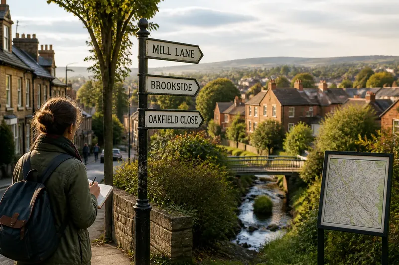
A place-name walk through an ordinary neighbourhood can begin at the nearest street sign. Read the name, then look around: does it point to a direction, a nearby feature, an older use of the land, or something less obvious? The aim is not to solve every name. It is to notice what each kind of name seems to describe, and where its clues stop.
Take a phone or pocket notebook, and choose a short route with several street signs, a district name on a map or noticeboard, and visible features such as a stream, green, slope or railway. Record exact spellings and locations before guessing at meanings. Treat every interpretation as a question to check, not a complete account of the neighbourhood.
1. What does the street name describe?
Start with street names because they are easy to compare as you walk. Some refer to a person, family, trade, plant, animal, direction or nearby landmark. Others use familiar forms such as Road, Lane, Crescent, Close or Square, which may suggest a layout or a local naming convention without revealing why that name was chosen.
Write the full name, including its ending, and note what lies along the street now. A name such as Mill Lane might prompt a search for a mill or watercourse, but the name alone does not establish that either was there. It could be inherited from a nearby place, applied later, or retained after the surroundings changed.
Look for clusters rather than treating each sign as a separate puzzle. Several names referring to trees might reflect a naming theme used by a housing development. A group of names associated with a former estate could point to a shared naming decision, not necessarily to buildings or events on the streets themselves.
Also notice changes in form. A street may have a name on the sign that differs from the version used on a local map, shopfront or bus stop. Record the versions without deciding which is historically original; the difference itself is a useful clue to how people refer to the place.
2. How does the district name frame the area?
District names usually cover more ground than a single street, but their edges may be hard to pin down. Find the name on a local map, community noticeboard or public sign, then note how far the label appears to extend. Do not assume that a named district has one agreed boundary simply because it is printed clearly.
Compare the district label with what people call the same area in everyday settings. A station, library or shop may use a different nearby place name, perhaps because it serves a wider catchment or sits close to a boundary. Keep those labels side by side: each may be useful for a different purpose.
Ask what kind of description the district name offers. It may refer to a landscape feature, a former settlement, a direction from a town centre, or a social or administrative division. Those possibilities are not interchangeable. A name can remain familiar even when the feature or local arrangement it once described is no longer visible.
For your notes, sketch the area as a loose shape and mark where each version of the name appears. This is not an attempt to settle a boundary dispute. It helps you see that a district label can act like a label on a drawer: handy for grouping, but not a precise account of everything inside it.
3. Which names point to visible features?
Now look for names attached to features rather than streets or broad districts. These might include a common, beck, hill, green, quay, wood, bridge or field. Check whether the named feature is visible from the route, marked on a map, or present only in a sign or local expression.
Match words to what you can observe, but avoid assuming that the current landscape explains the name fully. A stream may now run underground; a green may be a small planted space; a bridge name may survive after the structure has changed. The contrast between the word and the present scene is part of the observation, not a reason to dismiss the name.
Notice scale and position. A feature name may be used for a short stretch of road, a nearby housing area or a much larger patch of land. Mark the point where you encountered it and the object or area it seemed to refer to. If the reference is uncertain, write “possibly” rather than turning an impression into a fact.
Say you pass a sign for Brookside, but no open water is visible. You note the sign, trace the area on a map, and see a narrow blue line nearby; your sensible next observation is that the name may relate to that watercourse, while the name and map do not by themselves explain when it was named or how the stream has changed.
4. What can the wording tell you without telling the whole story?
Words in names can preserve a practical description: a slope, crossing, clearing, market or edge of a settlement. Look for repeated elements and compare them with the terrain or street pattern. A hill-related word on a rise is a stronger geographical clue than the same word encountered without any visible context, but neither makes a full history.
Pay attention to language and spelling. A name may contain an older local word, a shortened form, or a spelling that has shifted through maps and signs. If you recognise a possible meaning, jot it down as a lead and check a reliable local place-name reference or map source later. Similar-sounding words can have unrelated origins, so guesswork should stay labelled as guesswork.
Names can also carry choices about what a place should be called. A new road may be named after a landscape feature that has disappeared, while an older name may be replaced or adapted. A walk can reveal these layers of description, but not who made each choice, what alternatives were considered, or how residents received it.
Keep the distinction clear between observation and interpretation. “The lane runs beside a raised bank” is something you can see. “The name refers to an old defensive boundary” is a hypothesis that needs evidence beyond the resemblance between wording and terrain.
5. How can you compare names as you walk?
Use one simple note for each name: exact wording, where you saw it, what it appears to describe, and what remains uncertain. This keeps the exercise manageable and makes comparisons easier once you are home. A folded paper map works as well as a phone; mark the sign’s position rather than relying on memory.
- Street: Record the full name and its street-type ending; note nearby landmarks or a naming theme.
- District: Write where the label appears and whether other local signs use a different area name.
- Feature: Identify the visible or mapped object the name may refer to, if any.
- Language clue: Copy unfamiliar words exactly before looking up possible meanings.
- Uncertainty: Mark what you cannot verify, such as a former feature or an unclear boundary.
- Source to check: Note a local map, council place-name resource, archive catalogue or library reference that could help.
These notes are for careful looking, not for building a definitive account. Local archives and specialist references can offer more context, but their records may differ in scope or spelling. If a name matters for a formal address, boundary or official decision, use the relevant authority’s current information rather than a walking-note interpretation.
Which place-name questions are worth asking?
Can a street name prove that a feature once stood there?
No. It gives you a lead to investigate, not proof of a former feature. Check maps, local records or a specialist place-name source, and keep the name’s possible meaning separate from documented evidence.
Why might a neighbourhood have more than one name?
Different names may serve different purposes: a district label, a transport stop, a historic locality or a familiar name used by residents. Record where each version appears before assuming one has replaced the others.
What if a name seems to have no connection with the present landscape?
Note the mismatch and look for nearby clues on a map or in local records. The feature may have changed, the name may refer to a broader area, or your first interpretation may be wrong.
Where can I check a possible local meaning?
Start with current and historical maps, then look for council heritage material, a local archive or library catalogue, and a reputable place-name reference. Compare sources and keep any unresolved disagreement visible in your notes.
6. What should you leave unresolved?
Some names will resist a neat explanation, and that is a useful result. A sign can preserve a word after its reference has faded; a district can be recognisable without having a crisp edge; a street name can follow a developer’s theme rather than the land beneath it. Record those limits instead of filling gaps with a confident story.
At the end of the walk, choose one name from each scale: street, district and feature. Set them beside your notes and ask what each seems to describe, what source could clarify it, and what remains unknown. That small comparison is the point of a place-name walk through an ordinary neighbourhood: it lets familiar labels become distinct clues, without asking them to speak for the whole past of a place.
When you search for a place-name walk later, keep the same modest method: observe the wording, locate its use, and separate visible description from historical explanation. A neighbourhood’s names can guide a closer look, while leaving room for evidence you have not yet found.